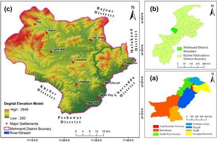
The management of groundwater systems is essential for nations that rely on groundwater as the principal source of communal water supply (e.g., Mohmand District of Pakistan). The work employed Remote Sensing and GIS datasets to ascertain the groundwater recharge zones (GWRZ) in the Mohmand District of Pakistan. Subsequently, a sensitivity analysis was conducted to examine the impact of geology and hydrologic factors on the variability of the GWRZ. The GWRZ was determined by employing weighted overlay analysis on thematic maps derived from datasets about drainage density, slope, geology, rainfall, lineament density, land use/land cover, and soil types. The use of multi-criteria decision analysis (MCDA) involves the utilization of the multi-influencing factor (MIF) and analytical hierarchy procedure (AHP) to allocate weights to the selected influencing factors. The MIF data found that very high groundwater recharge spanned 1.20%, high zones covered 40.44%, moderate zones covered 50.81%, and low zones covered 7.54%. In comparison, the AHP technique results suggest that 1.81% of the whole area is very high, 33.26 is high, 55.01% is moderate, and 9.92% has low groundwater potential. The geospatial-assisted multi-influencing factor approach helps increase conceptual knowledge of groundwater resources and evaluate possible groundwater zones.

The AHP and MIF analysis were employed in the study. The study employed AHP and MIF analysis within a geospatial framework to ascertain the GWRZ in the Mohmand District, Khyber Pakhtunkhwa (KPK), Pakistan. The geospatial framework was utilized to ascertain the GWRZ within the Mohmand District, KPK, Pakistan. The study incorporates several variables, namely lineament density, soil cover, lithology, land use, slope, rainfall, and drainage density. According to the AHP technique, the GWRZ received ratings of very high (1.81%), high (33.26%), moderate (55.01%), and low (9.92%). Based on the categorization conducted utilizing the MIF methodology, it is determined that 1.20% of the research area falls under the category of a very high rechargeable zone, 40.44% is classed as having a high recharge potential, 50.81% is categorized as possessing good recharge capabilities, and 7.54% is identified as having low recharge potential.
The integration of RS, GIS, AHP, and MIF techniques significantly enhances the comprehensive understanding of groundwater potential. Remote Sensing provides spatially and temporally detailed data, allowing for accurate mapping of surface characteristics and environmental parameters crucial for groundwater recharge assessment. GIS facilitates the efficient handling, analysis, and visualization of these spatial datasets, enabling the overlay and integration of multiple thematic layers. The AHP method aids in systematically evaluating and prioritizing these layers based on expert knowledge, ensuring that the most influential factors are weighted appropriately in the analysis. Meanwhile, the MIF approach further refines this process by assigning scores to major and minor influencing factors, ensuring a balanced and precise identification of potential groundwater zones. Together, these methodologies create a robust framework that enhances the accuracy and reliability of groundwater potential maps and supports effective decision-making for sustainable water resource management and planning.
In conclusion, this study underscores the critical importance of advanced geospatial techniques, such as AHP and MIF, in effectively identifying GWRZ in regions like Mohmand District, Pakistan. By integrating RS and GIS datasets, we have provided a comprehensive and reliable method to ascertain areas with varying groundwater potential. The sensitivity analysis further validated the impact of geologic and hydrologic factors on GWRZ variability, offering a nuanced understanding of groundwater dynamics. The findings demonstrate that employing such advanced methodologies enhances the accuracy and efficiency of groundwater potential mapping and facilitates better decision-making processes for sustainable water resource management. Moreover, this approach helps address the challenges posed by climate change and water scarcity, significantly contributing to global efforts in disaster management and environmental conservation. The practical implications of this research extend to policymakers, planners, and stakeholders involved in water resource management, enabling them to develop more informed and effective groundwater conservation and utilization strategies.
Sources:
Scientific Reports
https://www.nature.com/articles/s41598-024-70324-7#Abs1 .
Provided by the IKCEST Disaster Risk Reduction Knowledge Service System
Comment list ( 0 )
