Predicting natural disasters remains a critical challenge in geosciences, with the potential to save lives and reduce material damage. Despite significant technological advancements, achieving perfect accuracy in disaster forecasting is still unattainable. However, recent developments in artificial intelligence (AI) and machine learning are making substantial strides in this area. For example, AI algorithms have shown promising results in predicting earthquakes, as demonstrated by a 2023 study where AI accurately predicted 70% of earthquakes a week in advance. Volcanic eruptions are somewhat easier to predict through monitoring gas emissions, temperature, and volcanic activity, with platforms like MOUNTS and COMET using AI to process satellite images and ground observations. In hurricane forecasting, neural networks have significantly improved the accuracy of precipitation nowcasting. The continued advancement of AI, machine learning, and sensor technologies is enhancing the early detection and prediction of natural disasters, offering new opportunities to mitigate their impact. While perfect prediction remains elusive, these innovations represent significant progress in disaster mitigation efforts.
Predicting natural disasters is a cornerstone of geosciences. The ability to foresee tsunamis, earthquakes, volcanic eruptions, hurricanes, and floods can save countless lives and significantly reduce material damage. Despite substantial technological advancements, achieving 100% accuracy in predicting impending natural disasters remains elusive. However, substantial strides are being made: scientists are harnessing AI and machine learning to forecast cataclysms and mitigate their impact.
Earthquakes
It's possible to sense an impending catastrophe in advance. For instance, scientists recorded the strained state of Japan's lithosphere before the catastrophic Tohoku earthquake in March 2011, which claimed nearly 20,000 lives. However, despite advancements in seismic monitoring networks and data analysis algorithms, it remains challenging to pinpoint the exact time and location of an earthquake, although some scientific attempts have been successful. In 2023, researchers at the University of Texas at Austin published the results of a seven-month trial in China of an AI algorithm trained to detect statistical anomalies in real-time seismic data and historical earthquake records. In the experiment, AI accurately predicted 70% of earthquakes a week in advance, with 14 forecasts within 200 miles of the predicted location and matching the expected magnitudes. However, it also issued eight false alarms and missed one earthquake.
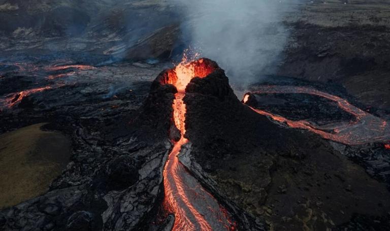
Volcanic Eruptions
Unlike earthquakes, volcanic eruptions can be predicted with greater accuracy. Monitoring gas emissions, temperature, and volcanic activity allows scientists to detect signs of an impending eruption. There are projects that monitor volcanic activity and analyze it using AI. In 2019, a group of researchers from the Technical University of Berlin and the Helmholtz Centre Potsdam developed the MOUNTS platform, which collects satellite images of volcanoes worldwide – from Russia and Japan to Colombia and Papua New Guinea – and processes them using AI. Information is available for each volcano, including sulfur dioxide emissions, temperature changes, and changes in topography. Historical observation data since 2000 is also available. Another project is the Centre for Observation and Modelling of Earthquakes, Volcanoes and Tectonics (COMET), which unites scientists from 14 UK universities. Using satellites, ground observations, and geophysical models, it collects data on 95 volcanoes: the dynamics of tectonic movements and maps of the probability of changes in the shape of volcanoes and the surrounding land, formed using machine learning methods. In 2021, the meteorological company Weathernews launched a volcanic ash detection system. It analyzes satellite images and recognizes volcanic ash in cloud gaps by its shape and texture. The system helps the company inform its customers about volcanic eruptions and the speed and direction of ash spread. This is particularly important for airlines in Japan and Southeast Asia, where many active volcanoes are located. Smoke and ash from volcanic eruptions can endanger flights due to poor visibility and the risk of engine damage. For example, the eruption of the Eyjafjallajökull volcano in Iceland in 2010 led to the closure of airports in about 30 countries and the cancellation of many flights. Typically, airlines make flight decisions based on information published by government agencies, but Weathernews' service can also be used to change flight plans or alert aircraft en route.
Hurricanes and Precipitation
Hurricane forecasting has become much more accurate thanks to satellite observations and computer modeling. Meteorologists can predict the formation of hurricanes long before they develop and track their trajectories. In 2022, researchers from IRT AESE Saint Exupéry and Météo-France developed three neural networks to forecast future precipitation. With their help, meteorological, government, and other organizations can predict the occurrence of hurricanes and other extreme weather events from one to six hours in advance. The networks were trained on a dataset of 20,400 weather maps – high-resolution images taken using radar technology in France in 2017-2018 over an area of approximately 1000x1000 km². "We propose the use of three popular deep learning models (U-net, ConvLSTM and SVG-LP) trained on two-dimensional precipitation maps for precipitation nowcasting," the researchers write in their article. These models accurately predict the future contour of precipitation. The work of French scientists could also be a step towards developing similar models for forecasting extreme weather events.
The Future of Disaster Mitigation
The development of artificial intelligence and machine learning promises to improve the analysis of large amounts of data and the identification of complex patterns that may indicate impending disasters. Improvements in sensor technology and the expansion of monitoring networks also contribute to earlier detection of hazardous natural phenomena. Russia is also using artificial intelligence in disaster prediction. For example, in 2022, the Emergency Situations Ministry began testing an AI system that identified potential wildfire and flood sites. In the first year of using the technology, the area of active fires in Yakutia decreased 16 times. According to expert forecasts, by 2027, systems that use artificial intelligence and big data to predict emergencies will appear in all major Russian regions. Although 100% accurate prediction of many natural disasters is still impossible, ongoing scientific and technological progress is improving humanity's ability to warn of natural disasters and mitigate their consequences.
Sources:
SAMSUNG E&A
https://tunza.eco-generation.org/ambassadorReportView.jsp?viewID=60736 .
Provided by the IKCEST Disaster Risk Reduction Knowledge Service System
Comment list ( 0 )

