NASA’s Disaster Program leverages open science to support disaster risk reduction, response, and recovery. During Hurricane Ida, NASA provided critical data, including soil moisture, flood detection, and power outage mapping, to aid recovery efforts. The Interagency Implementation and Advanced Concepts Team (IMPACT) used AI and satellite images to count blue tarps on rooftops, helping assess the damage severity. NASA, in partnership with IBM, is developing five open-source AI models trained on satellite data to improve disaster response by predicting flood risks, crop yields, and weather patterns. These models are designed to make data more accessible and help responders make faster, informed decisions. NASA’s Chief Science Data Officer, Kevin Murphy, highlighted that these AI models are efficient, adaptable, and validated, ensuring swift and effective disaster response while advancing scientific knowledge and enhancing resilience.

Empowered by NASA’s commitment to open science, the NASA Disasters Program supports disaster risk reduction, response, and recovery. A core element of the Disasters Program is providing trusted, timely, and actionable data to aid organizations actively responding to disasters.
Hurricane Ida made landfall in Louisiana Aug. 21, 2021, as a category 4 hurricane, one of the deadliest and most destructive hurricanes in the continental United States on record. The effects of the storm were widespread, causing devastating damage and affecting the lives of millions of people.
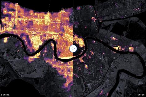
During Hurricane Ida, while first responders and other organizations addressed the storm’s impacts from the ground, the NASA Disasters program was able to provide a multitude of remotely sensed products. Some of the products and models included information on changes in soil moisture, changes in vegetation, precipitation accumulations, flood detection, and nighttime lights to help identify areas of power outages.
Using artificial intelligence (AI) with NASA satellite images, the Interagency Implementation and Advanced Concepts Team (IMPACT), based at NASA’s Marshall Space Flight Center in Huntsville, Alabama, conducted a study to detect the number of blue tarps on rooftops in the aftermath of hurricanes, such as Ida, as a way of characterizing the severity of damage in local communities.
Through an initiative led by NASA’s Office of the Chief Science Data Officer, NASA and IBM are developing five open-source artificial intelligence foundation models trained on NASA’s expansive satellite repositories. This effort will help make NASA’s vast, ever-growing amounts of data more accessible and usable. Leveraging NASA’s AI expertise allows users to make faster, more informed decisions. User applications of the Prithvi Earth Foundation Models could range from identifying flood risks and predicting crop yields to forecasting long range atmospheric weather patterns.
“NASA is dedicated to ensuring that our scientific data are accessible and beneficial to all. Our AI foundation models are scientifically validated and adaptable to new data, designed to maximize efficiency and lower technical barriers. This ensures that even in the face of challenging disasters, response teams can be swift and effective,” said Kevin Murphy, NASA’s chief science data officer. “Through these efforts, we’re not only advancing scientific frontiers, but also delivering tangible societal benefits, providing data that can safeguard lives and improve resilience against future threats.”
Source:
National Aeronautics and Space Administration
https://science.nasa.gov/open-science/artificial-intelligence-hurricane-response/ .
Provided by the IKCEST Disaster Risk Reduction Knowledge Service System
Comment list ( 0 )
