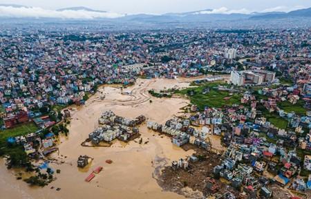
Climate change and urbanization are exacerbating the effects of flooding. A close look at a Nepalese river reveals that efforts to reduce the impact of floods must consider the geomorphic changes that occur during these extreme events.

In rapidly urbanizing areas, such as the Kathmandu Valley in Nepal, increasing population pressure is driving people to settle on floodplains. In many of these regions, the pace of development is highest in areas that are most at risk of flooding. To make such land available for urbanization, municipalities often turn to river engineering, building embankments that are designed to diminish this risk. But flooding is a multifaceted problem, and seemingly small factors can have dire consequences. Thapa et al. modelled the effects of embankments on flooding of the Nakkhu River, a small river in the Kathmandu Valley, and found that sediment movement has a profound impact on the effectiveness of these protective embankments.
Floods are more than just water. The devastation in Spain that began last month was a grave reminder that floods can carry debris — both natural (trees and other plants) and human-made (vehicles, building materials and other detritus). Large pieces of debris can become jammed behind bridges, creating temporary dams that increase the water level, and can result in the sudden release of a wave of water downstream.
But floods can also alter the geometry of the channel by eroding the bed and banks of a river, damaging flood-control structures and potentially leading to embankment breaches. Upstream erosion leads to the downstream deposition of sediment, such as stones, sand, silt and mud, which raises the riverbed and decreases the channel’s capacity. This can occur gradually over time, or quickly during a single flood, causing the river to flow over its banks or walls at ever-lower thresholds as more sediment is deposited.
The authors’ findings highlight the importance of including sediment and river-channel change in calculations of flood risk. Tragically, but perhaps not surprisingly, their predictions have already been put to the test. In late September, record rainfall hit central Nepal. Stations in the Kathmandu basin recorded up to 323.5 millimetres of rain in 24 hours, causing extreme flooding in many areas, including the Nakkhu River. The water flowed over the embankments, breaching them in at least one location, and inundating the floodplain. About 1,800 households in the district of Lalitpur were affected by the flooding of the Nakkhu and other rivers in the district.
In the area in which Thapa et al. conducted their study, satellite imagery shows that around 95% of the affected structures were constructed in the past 15 years, suggesting that — although the probability of flooding might have been raised by climate change — the disaster was closely linked to a surge in building on the risky floodplains. I walked through the affected area shortly after the event and saw first hand that sediment had indeed had a crucial role in exacerbating the impact of the flood. The deposition of sediment was evident, as was the reduced capacity in portions of the embanked channel, including the area just upstream from the catastrophic breach.
In the case of the Nakkhu River, it is clear that September’s flood vastly exceeded the capacity of the embankments, which were designed to contain only moderate floods (the sort that have happened roughly once every 25 years). This highlights another challenge associated with designing flood-mitigation measures in the face of climate change: the floods of the past are not adequate models for the floods of the present and future. This applies not only to the hydrology, but also to the geomorphic component of a flood, because extreme events can bring substantial levels of sediment erosion and deposition. The geomorphic changes that happen during an extreme event are often triggered by certain thresholds being crossed — for example, in the erosion of channel banks, the mobilization of coarse sediment or the occurrence of landslides. Such thresholds could well be difficult to anticipate if they have never previously been crossed.
Although Thapa et al. examined just one small river in a single city, their study serves as an example of the complexities involved in managing urban flood risk. As both the flood hazard and the exposure to floods increase around the world, a full analysis of both the hydrologic and the geomorphic processes of flooding is key to effective mitigation measures.
Sources:
NATURE
https://doi.org/10.1038/d41586-024-03773-9 .
Provided by the IKCEST Disaster Risk Reduction Knowledge Service System
Comment list ( 0 )
