Ridges as Indicators of Terrane Differences
Both ridge densities and azimuthal orientations of the two most prominent ridge trends showed notable differences among the terranes examined, but this was not subjected to rigorous statistical testing. A causative model for the differences in trends is proposed. The Klamath terrane study is summarized as follows: 1) there are real and meaningful differences in some geomorphic parameters when these are associated with individual terranes - this confirms the hypothesis that such differences should in fact be expected owing to the natural variations in rock type/structure in diverse terranes that come from different parts of the mobile plate system and arrive at different times; 2) Landsat could distinguish some of the Klamath terranes simply by visual inspection; and 3) stereo achievable with SPOT imagery allows certain measurements otherwise obtainable only from topographic maps to be made.
Ridges as Indicators of Terrane Differences

This density value relates to several factors, chief being the “fineness” of the drainage network.
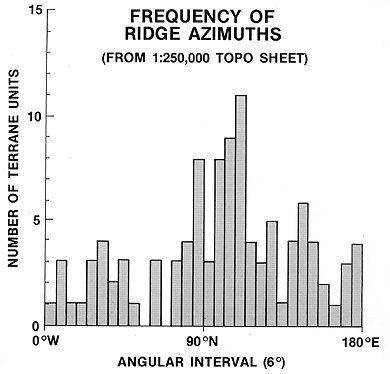
Then, using the above-mentioned program, in which the ridge data are entered as points on a digital plotting board that converts them to lines, their average trend directions were then calculated. These orientations of the ridges for any chosen area (such as a terrane or fraction thereof) were then plotted in rose diagrams similar to those shown above for the Elk and Sixes Rivers terranes. Below is a map, on which is drawn the most common orientation interval (in 5° units) in red and the second most common in blue.

The prevailing direction for terranes including and east of the Yolla Bolly terrane is north-north-east, in keeping with the regional plot just shown. But, in the Elk and Sixes River terranes that direction becomes northwest.

In upper panel I, a new terrane smashes into the continental craton along a subduction line of a given geometry (including orientation). As the terrane slides under (or, it can override the continent), it takes on a fabric whose principal direction(s) is governed by the stress field imposed during emplacement. Now, in panel II, the subduction zone location and geometry have changed and a somewhat different fabric orientation results. In panel III, a new subduction zone (bounded by a transform fault [not shown]) adopts a notably shifted orientation and this passes on to the docking terrane. Then, as erosive processes gradually carve out topographic expressions for the terrane group, streams, whose paths tend to be controlled by underlying structural fabric, produce valleys and intervening divides that reveal the effects of the stress fields by preferred orientations.
` <>`__17-22: Before you go on to the (next) summary statement, from what you have read what seems to be the best parameter(s) for separating terranes by geomorphic properties? `ANSWER <Sect17_answers.html#17-22>`__
Summary of the Klamath Terrane Project
The foregoing report on the writer’s research into terrane/terrain interrelations is, as stated, incomplete. But, it warrants several conclusions:
Real differences in geomorphic expression exist among the terranes. We can separate the Klamath terranes best by ridge (and stream) density differences.
Variations in hypsometric interval (curve) and related parameters among terranes may indicate relative resistance to erosion. That resistance depends on rock types and locations within the Klamath “dome”.
Principal directions of ridge orientations seemingly differ in individual (or clusters of) terranes. This is probably structurally controlled and could relate to subduction/accretion geometry.
The principal value of space imagery is that it provides a visual overview of differences in landforms/topography expression. It helps to pinpoint areas for quantitative analysis by conventional morphometric methods.
We require stereo imagery for elevation-based morphometry and structural pattern analysis. SPOT-type stereo imagery reduces the illumination bias.
` <>`__17-23: What, in your opinion, is (currently) the principal value of space imagery in geomorphic analysis of accreted terranes (and perhaps landforms in general)? `ANSWER <Sect17_answers.html#17-23>`__
The bottom line: Remote Sensing has a limited but positive role in the analysis of landforms, by virtue of its excellence in creating synoptic images that highlight regional relationships that we can interpret visually. This role will increase significantly as high resolution stereo becomes commonplace from space sensors. Ultimately, this imagery will lead to the topological expression of surfaces in a quantitative mode that will prove its worth again, as it has from aerial photography, as a prime approach to geomorphic characterization.