Geomorphology from Space
This page reviews the background (history) of the Workshop on Global Geomorphology, held near Tucson, AZ in 1985. From this came a commission from NASA Headquarters to develop and publish Geomorphology from Space. Instructions on how to obtain the CD-ROM of that now out-of-print book, or access it on the Web, are given. As part of the book, Robert Hayden prepared several geomorphic maps made exclusively from Landsat imagery, an example of which is shown.
Geomorphology from Space
There was an almost immediate payoff. The writer received NASA funding to prepare a publication that focused on using space images to characterize landforms. Joined by Robert Blair, Jr of Fort Lewis College, Durango, CO, as co-editor, we assembled fourteen scientists (including ourselves) to write twelve chapters, each covering a different geomorphic theme, in a 717 page book entitled: Geomorphology from Space: A Global Overview of Regional Landforms (NASA SP-486), which appeared at the end of 1986. Although we distributed 4,000 copies, the book did not, at first, receive adequate publicity. In recent years, authorities have acknowledged it as an invaluable compendium of geomorphic information, as well as a comprehensive survey of the world’s geology, and it has led to renewed interest in regional analysis.
Unfortunately, there was no second printing, so NASA and the U.S. Government Printing Office (GPO) cannot fill requests for copies. But, NASA leaders recognized its value, so people in the educational program at the Jet Propulsion Laboratory (JPL) decided to add it to their growing set of CD-ROMs, available at low cost to professionals and the public. The staff at NASA’s Goddard Space Flight Center did much of the scanning and layout, so this reproduction of NASA SP-486 with a new format now is available from JPL, with a limited quantity of CD-ROMs free to educators. A version of the book is also accessible on the Web at: http://daac.gsfc.nasa.gov/DAAC_DOCS/geomorphology/GEO_HOME_PAGE.html
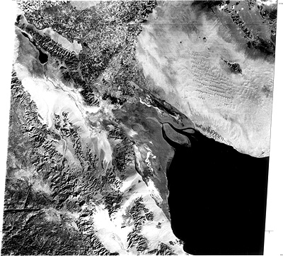
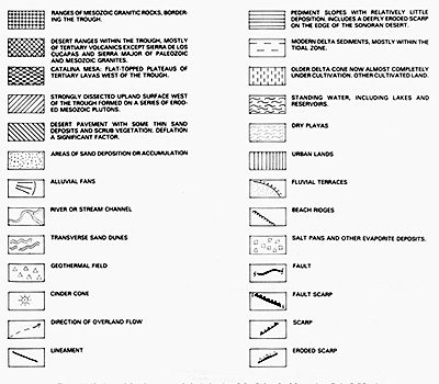
One of the serendipitous outcomes of this book is that Dr. Robert S. Hayden was persuaded to prepare several geomorphic maps from full and partial Landsat images, as a demonstration of the possibilities of mapping at this scale from space imagery. We reproduce here a Landsat-2 image of the upper Gulf of California (mostly in Mexico) and the beginning of Baja California. Below it is his geomorphic map, with key:

“Geomorphology from Space” contains nine thematic chapters: Tectonic Landforms, Volcanic, Fluvial, Deltaic, Coastal, Karst/Lakes, Eolian, Glacial, and Planetary Landforms. These chapters contain many stunning and revelatory images, all open to inspection on the CD-ROM and the Internet. To whet your curiosity, we now present two or more representative examples for each theme (except Planetary, which we thoroughly treat in Section 19), along with a brief description of what we extract from the image regarding geomorphology and general geology.