Karst/Lacustrine/Aeolian/Glacial Landforms
Other processes besides running water modify the Earth�s surface. Percolating ground water can dissolve sedimentary carbonate rocks, leaving sinkholes and other bedrock irregularities that fall into the category of Karst topography. Wind can alter surface materials, especially in desert climates, both by erosion and by deposition. Great accumulations of ice flow under its own weight, carving out mountainous terrain in valley or piedmont glaciers and cutting away at the surface as continental-scale ice sheets spread great distances. Parts of continents subjected to Pleistocene glaciation also have distinctive landforms due to deposition of debris eroded by these ice masses.
Karst/Lacustrine/Aeolian/Glacial Landforms
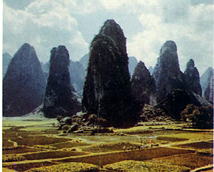

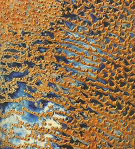
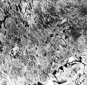
The karst topography in this scene appears in the darker-toned surfaces. These karsts are a thick series of carbonate rocks that elsewhere in the image have their outer rock removed to expose older non-carbonates underneath. Two main joint sets criss-cross the carbonate sequence and enlarge into intersecting valleys. Drainage across these plateaus is now mostly internal, so that the region also contains numerous caves. This scene offers a remarkable illustration of how dissimilar rock types (which host different joint spacings) give rise to strikingly varied topographic expressions and resulting landforms
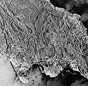
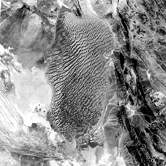
The island of Jamaica in the Caribbean is composed mostly of limestones. As such, it is subject to intensive karst development in response to high annual rainfall. This Seasat radar image shows the typical karst topography developed under subtropical conditions.
` <>`__17-11: What common feature of internal drainage (both groundwater and underground streams), quite popular to visit, is frequently associated karst topography? `ANSWER <Sect17_answers.html#17-11>`__
northwest Alaska.|
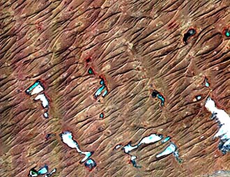
The first image shows elongated, thermokarst lakes in the coastal plains ending at Point Barrow in northwest Alaska. The lakes tend to be ovoid and elliptical and are generally less than 6 m (20 ft) deep. They result from collapse, slumping, and caving during the summer thaw of soils and sediments affected by permafrost (a condition in which groundwater in upper layers freezes permanently to some depth, except for upper layers, heated in the warm season. The cause of elongation is uncertain but may be due to paleowind control at a time when winds came from the northwest, rather than today’s northeast.
The continental glaciers of the Pleistocene Epoch reached into today’s northern states east of the Great Plains. Deep gouging of the relatively soft sedimentary rocks produced big and variably deep depressions that have filled with water since the last glacial retreat some 8000 years ago. These produced today’s Great Lakes, which collectively are the largest grouping of fresh-water lakes in the world. Here they are in this Landsat mosaic (lakes identified in the caption):

Lakes have several different origins, the most common being simply accumulation of surface waters (sometimes aided by groundwater) in depressions. Lakes tend to be transient; most smaller ones last only hundreds to thousands of years. Water draining into enclosed (landlocked) mountainous terrain can be trapped for a while, building up lakes. In arid climates, these may be ephemeral to the extent that they contain water only part of each year during the rainy season. A playa is a lake bed formed in an arid climate by rapid evaporation during dry season of wet-season stream inflow causing sediment and salt deposits (evaporites) to accumulate over time.
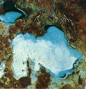
The huge lake (more than 9,000 km2 [3,475 mi2]) in the image above is the Salar de Uyuni in Bolivia, the largest salt playa in the world. In this March 1973 image, the salar (salt pan) has about a meter of briny water (blue). Some of the surface is uncovered salt (white), which, in addition to sodium chloride, NaCl (rock salt) and calcium sulfate, CaSO4, also contains lithium chloride, LiCl, making this the biggest source of lithium in the world. This, and the Salar de Coipasa (upper left), were once part of a much bigger lake that had formed in this part of the Altiplano province of the Andes, during a rainier climate in the past.
` <>`__17-13: What is the eventual likely fate of these salars? `ANSWER <Sect17_answers.html#17-13>`__
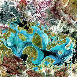
Similar to some salars are ephemeral lakes - those that fill to shallow depths during extended periods of wet seasons but during droughts dry up until the next periods of rainfall. A good example is Lake Carnegie in Australia; here is one of its filling phases.
Our first example shows star dunes is found in the Grand Erg Orientale, a Sahara Desert member here at the border of Algeria with Libya. These appear as roughly equi-sided hills rising in some cases more than 100 m (330 ft) above the sandy base:
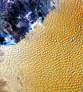
The largest active sand sea on Earth (560,000 km2 [216,237 mi2]) is the Rub’al Khali or Empty Quarter, shown above, in the southern Arabian Peninsula. Loose sand, up to several hundred meters thick, covers most of the solid rock landscape in this region. In the Landsat scene below, six distinct sand fields, each characterized by particular types of dunes (distinguished mainly by shape), occupy the entire area. Of these, we mention four. Most of the center consists of Complex Crescentic Dunes on the left and Complex Linear Dunes on the right. In the lower right corner are Star Dunes, and along the left is a separate sea consisting of small Linear and Complex dunes.
The ASTER sensor onboard Terra has generated false-color images of some of these Empty Quarter dunes )longitudinal type) in southern Saudi Arabia. In the version below, dunes are bright yellow and brown whereas the blue relates to the spectral response of interdune clays and silts.
For comparison, look at these more widely spaced longitudinal dunes in the Egyptian desert
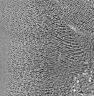
Elsewhere in the Rub’ al Khali are these unusual seif dunes, with arrowlike point upwind, and again blue area which denote some surficial moisture.
A variant of these seif dunes, also found in Saudi Arabia, shows them to be extensively interlocked.

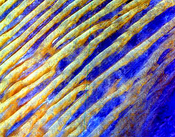
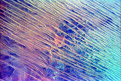
The image below is part of the Dasht-E-Lut, or stony desert, located in southeast Iran. Dominating the scene is a large, but isolated, sand sea containing linear or elongated star dunes with a prevailing northeast trend. The surrounding lowlands have gravelly surfaces. Along the lower left edge of this Landsat image are dark streaks that orient towards the southeast. These streaks are the eastern end of a big complex of long, narrow ridges called yardangs, left behind when winds blew out soft clay/sand sediments, leaving trenches. As the trenches elongated, they controlled the eventual scooping out of the linear valleys that defined the residual yardangs. In this scene, exposed bedrock comprise the low mountains to the east of the sand sea, from which streams carry and deposit dark rocks in a series of distributaries and fans.
Further to the east, in the Thar Desert of western India, strongly crescentic dunes have formed, as well displayed in this ASTER subscene:
` <>`__17-14: Can sand dunes ever be vegetated? `ANSWER <Sect17_answers.html#17-14>`__
The above aeolian views feature sand dunes. But many have the misconception that deserts are mostly sand. In fact, most of the desert terrain in the world is rocky, often with gravel surfaces or thin fragmental soil. Some weird terranes can form in arid lands where the wind blows persistently. Sand blast sculpturing is a common process, leaving odd-shaped forms that in space imagery really stands out. Consider this Landsat image of the Tanezrouft Basin of southern Algeria. The Sahara, of which this a part, is mainly rocky rather than sandy in cover. Here sculpturing has carved out deflation basins within horizontal to gently dipping sedimentary rocks. Patterns that tend towards circular are the mark of this kind of terrain, but on the ground the effect would probably go unnoticed.
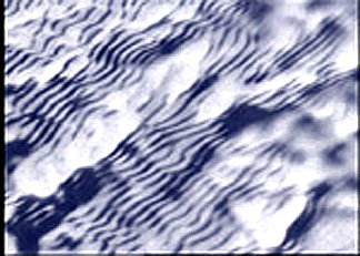
Sand dunes usually are made up of sand- and sil-sized particles. But it is possible for winds to produce regular-spaced dunes composed of snow flakes and particles, as shown in this image of a snow field in the Antarctic.

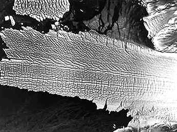
The above image is a special, false-color image, using yellow, red, and blue filters, to enhance various types of ice and glacial zones. It shows the thick ice cap (defined as a dome-shaped ice mass with radial flow) known as Vatnajökull, in south-central Iceland which has 43 outlet glaciers (light blue), many with lobate termini. Areas in yellow-orange are vegetated, while reds associate with basaltic rocks and sparse vegetation. Green in the ocean is sediment, and black around the ice cap is a zone of ground soaking from glacial meltwater.
On a smaller scale, Byolot Island in the Arctic Sea of northern Canada is capped by a small permanent icefield, from which mountain glaciers are flowing downslope on both the north and south sides:

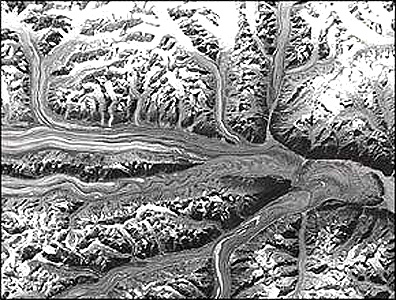
The image mosaic below shows typical alpine or mountain glaciers developed from snow fields covering the higher elevations of parts of the Wrangell and Chugach mountains of southeast Alaska. The first range rises to 5,043 m (16,541 ft) at Mount Kennedy. Among the large glaciers are Nabesna (to the north), Kennecott and Rohn sending meltwater into the Chitina River, and Russell and Barnard coming off the eastern segment of the Wrangell group. In the Chugach, within the scene, the highest peak is Mount Tom White (3270 m; 10630) but higher peaks are found both to the west and east. The Bering glacier is the largest in the Chugach group, although not as broad as the Malaspina glacier off the image to the east. Note the dark streaks in some of these piedmont glaciers. These are medial and lateral moraines (glacial debris that may become rock deposits). The reds in the scene are mostly tundra vegetation.
southern coast of upper Alaska, seen in this Landsat two image mosaic.|
` <>`__17-15: What would be the appearance of the terrain if all the glaciers in the Chugach Mountains were to melt and disappear? `ANSWER <Sect17_answers.html#17-15>`__
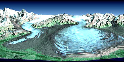
Along the same southern coast of Alaska is a famed active glacier known as the Malaspina Glacier. The Landsat subscene below shows a series of internal moraines on the glacier and a prominent wide lateral moraine to the west (left).
of Alaska.|
The perspective view of this glacier as it creeps towards the Gulf of Alaska, made by combining Landsat and STRM data, whows it in context with its mountain source:
Glaciers tend to have black streaks on their surfaces - these are medial moraine deposits formed as rock falls loose at the head of the glacier and continues this process over the years, so that the debris are strung out as streaks that move over the years. The Walsh glacier in Alaska, imaged from space by the KH-7 military satellite, shows this feature:
This JERS-1 SAR (radar) image of an Alaskan glacier brings out the details in the cracking of the ice as the entire mass moves slowly down gradient.
Glaciers appear wherever it is cold enough year round for periods of extensive snowfall. As the snow compacts, pressure aids in its melting and refreezing as ice. Almost all glaciers appear either in the cold high latitudes of both global hemispheres or where mountains rise to heights that remain cold much of the year (glaciers occur near to top of Mount Kilimanjaro in Kenya near the Equator). In the southern hemisphere glaciers occur in New Zealand and in South America, as this ASTER view of a mountain (valley-filling) glacier in the Andes displays so well (the time of the year is the southern summer [around December]):

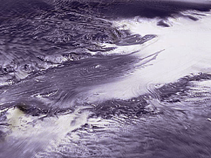
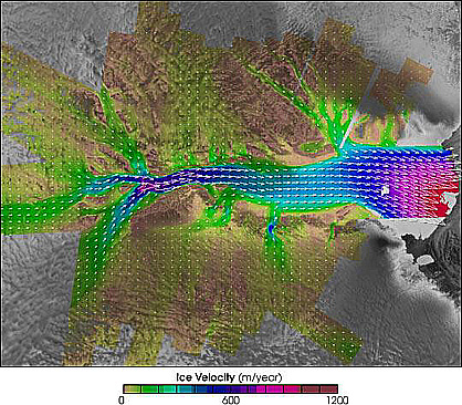
The largest and longest glacier in the world is the Lambert Glacier, in northeastern Antarctica (Australian sector), which meets the sea at the Amery Ice Shelf. Its length is given as 403 km (250 miles); it width reaches to 64 km (40 miles). Below are two space images: the top shows part of the glacier; the bottom displays rates of flow determined from radar data taken over an extended period:
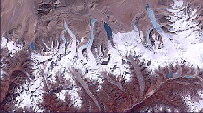
Evidence is growing that most of the world’s glaciers are retreating in the last 30 years, probably in response to either a natural interglacial warming or man-induced global warming, or perhaps both. Glaciers in the Himalayas show this continuing condition. The mountain glaciers in Bhutan shown here are shrinking and developing new lakes at their termini - solid indications of diminishing glacial active in that region.
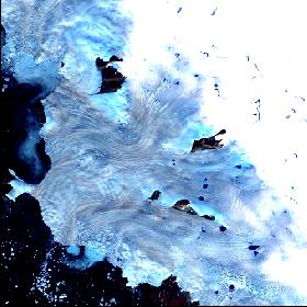
Glaciers also come off great ice sheets such as the one covering most of Greenland. This view (ASTER) shows the sheet’s edge and flowing glacial ice emptying into Baffin Bay on the northwest corner of this subcontinent (across from Ellesmere Island and north of the Thule Air Base).
What does a landscape once dominated by valley glaciers and ice sheets look like when the ice cover has melted? This partial Landsat scene in the Trollaskagi region of northwest Iceland provide a post-ice view of an ice-sculpted mountainous area where glaciers, now gone, have left conspicuous troughs (wide valleys) with intervening ridges now sharply creased into aretes. Several large fjords are formed where seawater has encroached into larger glacially-scoured lowlands.
of Iceland, in this partial Landsat image.|
Ice is conspicuous from space and vast areas like the Antarctic and Greenland appear almost completely covered with it. In the last 2 million years, these ice centers had expanded and, particularly in the northern hemisphere, ice miles thick moved from the polar regions into Siberia, northern Europe, and in the U.S as far south as Cincinnati and into the northern Great Plains. Several advances and retreats occur. Today with that ice almost gone from North America, the land once covered has been notably modified by both erosional and depositional glacial landforms. Deposits of moraine and till in places are several hundred meters thick. Depositional landforms are harder to make out in many space images but here are two examples, both from Canada.
The first shows glacial scouring, fluting, alignment of lakes, and morainal surfaces and till plains in the Northwest Territories.
This second image is a Landsat subscene that shows megafluting (areas of scraping kilometers wide) in the Nunavat Territory of Arctic Canada.

The third is a Landsat MSS subscene that includes a field or swarm of drumlins, elongated low, cigar-like hills of glacial till that were molded into this shape during a moderate glacial advance. They appear after the ice melts and retreats. Note the direction of motion from the northeast.
Seasat viewed a large drumlin swarm in northwest Ireland, as seen here. The term “drumlin” is Irish, being given long ago to these peculiar hills.

Compare the (difficult to see) shape of the drumlins in the Landsat and Seasat subscenes with an aerial photo of these landforms.
hills points in the direction of ice advance.|
This ends our tour of highlighted, thematic images from “Geomorphology from Space.” You can see more, with detailed captions, on the Internet Site mentioned above or in the CD-ROM prepared by JPL. If you study the book, the Web Site, or the CD-ROM, please look at Chapter 11 that presents an effort by Dr. Robert S. Hayden to demonstrate the value of Landsat imagery in geomorphic mapping. Although he was not the first to produce this type of map solely from space imagery (C.F. Pain’s 1985 map of an area in New South Wales, Australia is the earliest known to the writer), he has put together excellent examples of this capability.