The avalanche incident occurred in Naran, northern Pakistan on March 21, 2024, which submerged houses and hotels, served as a trigger for further in-depth analysis of avalanche risks in the downstream towns and villages. Through comprehensive multi-case studies, it was found that the phenomenon of snow melting into water before heavy precipitation warrants particular vigilance, as it greatly increases the likelihood of avalanches. The spatial-temporal distribution of daily total precipitation was obtained by analyzing data from the Global Precipitation Measurement (GPM) for each day, facilitating an analysis of daily precipitation variations in the region. Subsequently, the Knowledge-Driven Flood Intelligent Monitoring (KDFIM) algorithm, combined with the free accessible Sentinel-1 and Sentinel-2 images of Copernicus Programme, was utilized to infer areas where snow melting into water on ground or slope surface, enabling the identification of early warning signs of snow melting before avalanches. Finally, GF-1B imagery, obtained on March 23 with 2m spatial resolution, from the Land Satellite Remote Sensing Application Center, Ministry of Natural Resources of China, was utilized to analyze the avalanches and assess potential avalanche risks nearby Naran town as in Figure. 1.
Fig.1 depicts that areas A1 and A2 had experienced avalanche events prior to March 21, while the avalanche source on March 21 was identified in area A3. Further validation of locally captured videos from multiple angles confirmed the affected area as A3. Subsequently, employing the same methodology and leveraging the SAR data with 1m spatial resolution, provided by SPACETY satellite Fucheng-1 of China on March 25, and jointly supported by Sentinel-1 and Sentinel-2 images of Copernicus Programme, additional risk analysis was conducted for the segment of Mansehra-Naran-Jalkhad-Chilas Road (N15) from GPS Dum Duma to the Saeed Swati hospital area, the results are illustrated in Figure 2.
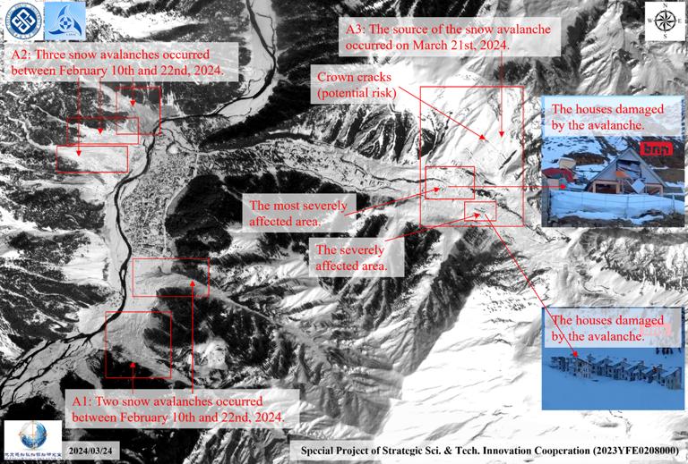
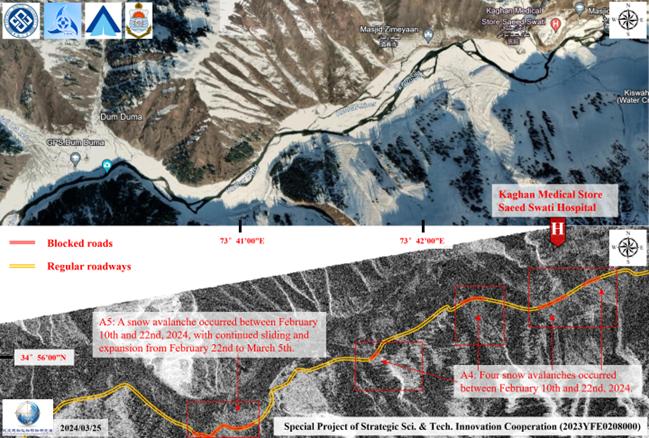
Fig. 2 clearly indicates that prior to the March 21 avalanche near Naran town, four avalanche events had occurred in area A4, leading to certain blockages along the Road N15 from GPS Dum Duma to Saeed Swati hospital. Additionally, continuous expansion of avalanches was observed in area A5, causing repeated damage or coverage to the roads. To further understand the impact of this continuous heavy precipitation on the entire region, comprehensive blockage analysis of the large area along the Road N15 was conducted using the post-disaster GF-1B data observed on March 23, as depicted in Figure 3.
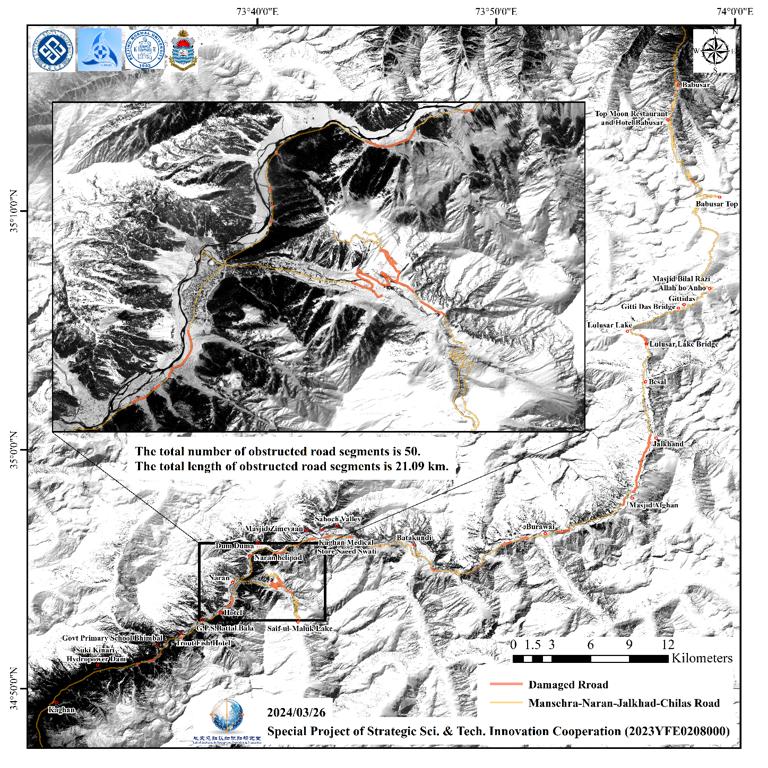
Upon comprehensive assessment on Fig. 3, it is discerned that the Road N15 had experienced significant blockages predominantly concentrated in the vicinity of Naran, attributable to the interplay of multiple rounds of heavy precipitation and steep terrain in the precipitous mountainous region. Conversely, the northern and southern sections, characterized by relatively gentle slopes, primarily suffered from thick snow cover, resulting in less road damage from avalanches. The total number of road segments affected by avalanches along the Road N15 in the imaging area amounts to 50, with a cumulative length of 21.09 kilometers. This presents a substantial challenge for emergency rescue operations and transportation recovery in the affected areas. The expedited restoration of road accessibility stands as a critical concern in the current scenario.
The map shown in Figure 1, 2, and 3 was produced by the team of the Special Project of Strategic Sci. & Cooperation: Developing Satellite Emergency-Response System and Using for Typical Major Natural Hazards (2023YFE0208000), on March 24, March 25 and March 26, respectively. The maps were passed to the concerned PDMA, KDA and NDMA of Pakistan immediately after its production in Central South University in Changsha, China.
(Team leader and supervisor: Prof. Lixin Wu; Image analysis: Prof. Lixin Wu and Dr students Zhijun Jiao; Map producer: Dr students Zhijun Jiao, Rabia Rasheed, and Zhimei Zhang; Caption writer: Dr students Rabia Rasheed and Zhijun Jiao; Corresponding: Prof. Lixin Wu, E-mail address: wulx66@csu.edu.cn )
Lab of Geohazards Perception, Cognition and Prediction, Central South University Changsha, 410083, China
March 27, 2024
Provided by the IKCEST Disaster Risk Reduction Knowledge Service System
Comment list ( 0 )

