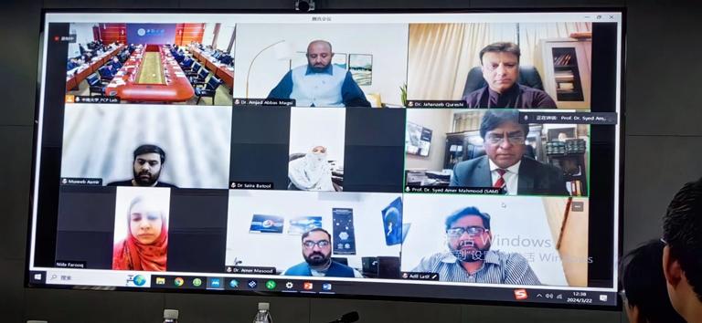
The launch meeting of the "Strategic Science and Technology Innovation Cooperation" key special project (the first batch) "Development and Application Demonstration of Satellite Emergency Technology System for Typical Major Natural Disasters" led by Central South University was held in the third conference room of the Science and Education Building of Central South University (CSU) on March 22nd, 2024. Professor Wu Lixin, an Academician of Eurasia Academy of Science, from the School of Geosciences and Info-Physics, Central South University serves as the project leader. Professor Guo Xueyi, Vice President of CSU, Professor Yin Gang, Director of the International Cooperation and Exchange Department of CSU, Professor Gan Xueping, Vice Director of the Research Department of CSU, Professor Amjad Abbas Magsi, Chairman of the Academic Committee of Punjab University in Pakistan, Professor Syed Amer Mahmood from the Department of Space Science of Punjab University, and relevant leaders of other project units attended the meeting.

The project is led by CSU in collaboration with Beijing Normal University, University of Electronic Science and Technology of China, Land Satellite Remote Sensing Application Center of the Ministry of Natural Resources, and Institute of Geographic Sciences and Natural Resources Research, Chinese Academy of Sciences. The project has established four research topics, which are: "Remote sensing investigation of disaster vulnerabilities, risk identification, and comprehensive forecasting", "Emergency satellite focused monitoring of disasters and rapid extraction of key disaster elements", "Rapid collection of multimodal emergency data and intelligent assessment technology for disaster damage and loss", "Technical platform and application demonstration for major Disaster Reduction Services for the Belt-and-Road (DRS4BR)".
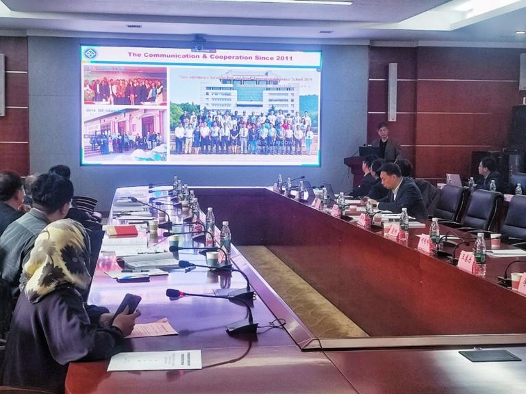
Prof. Wu Lixin's team, leveraging key platforms such as the State Key Laboratory of Remote Sensing Science, the Key Laboratory of Geospatial Information and Smart Service for Natural Resources of the Ministry of Natural Resources, and the International Research Center for Cooperation on Disaster Risk Reduction, as well as international networks like the Disaster Risk Reduction Knowledge Service (DRR) of International Knowledge Centre for Engineering Sciences and Technology (IKCEST) under the Auspices of UNESCO, has accumulated substantial research experience in the areas of disaster vulnerability investigation, satellite emergency observation, rapid disaster situation identification, precise disaster damage assessment, disaster knowledge service, and international cooperation. Since the "Wenchuan Earthquake" in 2008, a research team has naturally formed around the monitoring of major natural disasters, disaster assessment, and emergency service, which has a foundation of long-term collaboration. Under the funding of projects supported by the 973, 863, the Science and Technology Support Program, the Key Research and Development Plan, the National Natural Science Foundation of China, and the National Disaster Reduction Committee's satellite disaster reduction special projects, the team has achieved a lot in the areas of disaster science research and satellite monitoring analysis, as well as emergency service technology for spatial information (Such as the remote sensing identification of pre-earthquake anomalies, the risk analysis of landslide and flood, the InSAR deformation calculation cloud platform, the IKCEST-DRR under the Auspices of UNESCO, the crowd-sourced data cleaning and aggregation software platform, and the forest and grassland fire risk early warning monitoring system, etc.).
Facing the lack of independent satellite resources and weak disaster prevention and mitigation technology in the "Belt and Road" co-construction countries, which make it difficult for them to respond passively and effectively in the face of major natural disasters. By utilizing China's remote sensing satellite resources and leveraging the country's strengths in spatial information and disaster prevention and mitigation technologies, the project aims to develop a satellite emergency technology system for typical major natural disasters. It will carry out emergency monitoring and application demonstrations using China satellites, expand regional natural disaster emergency cooperation, and contribute Chinese wisdom and solutions to international disaster prevention and mitigation. A panel of top scientists and engineers in the field attended the launching meeting, including Prof. Wang Qiao from Beijing Normal University, who is an Academician of Chinese Academy of Engineering, Professor Gong Huili from Capital Normal University, who is an Academician of Eurasia Academy of Science, and Prof. Shen Xuhui from the Natioal Space Center, CAS, Prof. Sheng Qian from the Institute of Rock and Soil Mechanics, CAS, Prof. Li Ainong, from the Institute of Mountain Hazards and Environment, CAS, Prof. Du Peijun from Nanjing University, and Prof. Ge Daqing, a professor-level senior engineer from the Aeronautical Geophysical and Remote Sensing Center, Ministry of Natural Resources of China, who provided technical guidance and professional support.
Prof. Wang Qiao and Prof. Gong Huili co-chaired the consultation meeting on project implementation plan, combining both online and offline. Prof. Wu Lixin, the project leader, along with the leaders of each research topic, provided a detailed report on the overall situation of the project, covering aspects such as the background of the project initiation, research content and implementation plan, indicators and expected outcomes, the R&D team and their foundational work, and organizational management. The expert group affirmed the implementation plan and the preliminary work of the project team, agreeing that the project should proceed as soon as possible. They also offered valuable opinions and suggestions regarding key technological breakthroughs, collaboration among the institutions, and the practical application the project's outcomes and demonstration of the platform DRS4BR.
Provided by the IKCEST Disaster Risk Reduction Knowledge Service System
Comment list ( 0 )

