Despite considerable advances in flood forecasting during recent decades, state-of-the-art, operational flood early warning systems (FEWS) need to be equipped with near-real-time inundation and impact forecasts and their associated uncertainties. High-resolution, impact-based flood forecasts provide insightful information for better-informed decisions and tailored emergency actions. Valuable information can now be provided to local authorities for risk-based decision-making by utilising high-resolution lead-time maps and potential impacts to buildings and infrastructures. Here, we demonstrate a comprehensive floodplain inundation hindcast of the 2021 European Summer Flood illustrating these possibilities for better disaster preparedness, offering a 17-hour lead time for informed and advisable actions.
This study demonstrates that recent advancements in hydrologic and hydrodynamic models and computational capabilities enable high-resolution flood inundation and impact forecasting within operational FEWS even for comparatively small and fast-reacting rivers. These forecasts encompass probabilistic inundation maps and identify buildings and transportation infrastructure at risk of flooding. Operational inundation and impact modelling provide much richer information on the space and time dynamics of flooding and its effects.
Flood depth and flow velocities are not only available at a few gauge locations, but continuously and consistently in space. Time-varying characteristics such as lead time to specific depth thresholds or the rate of water rise can be provided during the course of the entire event. At last, the prediction of affected buildings and critical infrastructure are compared against emergency mapping products derived from satellite data. Current satellite inundation maps, given their prioritisation of rapid mapping over quality, should not be regarded as absolute truth, leading to inherent uncertainties. Using Synthetic Aperture Radar (SAR) for emergency mapping of floods may have some limitations, such as misclassification and timing issues. This highlights the need for caution and an acknowledgement of the upper limits of SAR-based flood detection methods when identifying affected areas and assessing damages.
The feasibility of the operational flood impact forecasting was demonstrated in the hindcast of the 2021 European Summer Flood event in the Ahr basin in this study. Several challenges, however, remain as this study progress in adopting impact-based FEWS:
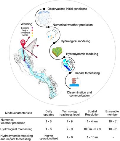
(1) An increasing number of national hydro-meteorological services are investing in a paradigm shift from traditional FEWS to high-resolution, impact-based FEWS. However, implementing real-time services on a national scale poses challenges, given the trade-offs involving computational power, operational service scheduling, and data storage archiving.
(2) Availability of quality data and computational resources is crucial for implementing near-real-time flood impact forecasting. Many regions, especially flood-prone areas, lack essential datasets such as high-resolution soil and terrain data, real-time meteorological observations, and high-resolution atmospheric forecasts. Continuous and long-term discharge measurements are also essential for flood monitoring, model calibration and warning threshold establishment.
(3) NWPs still have uncertainties due to factors like ensemble size, model structure, and how small-scale convection processes are represented. Real-time precipitation can be underestimated and therefore needs to be post-processed for better accuracy.
(4) The complexity of data integration and validation poses an additional challenge. The integration of workflow managers like ecFlow, complemented by a user-friendly graphical interface, streamlines the scheduling of operational services. This not only enhances user engagement and accessibility but also contributes to the optimisation of service delivery in real-time hydrodynamic modelling and forecasting.
(5) Evaluating the performance of FEWS can be difficult, especially when hindcast data is not available and NWP models have limited operational history. Ensuring the reliability of FEWS is critical to respond quickly to predicted events. It helps avoid the cry wolf effect, where too many false alarms make people and authorities less likely to act promptly during real flood threats.
(6) The prediction of rare, extreme flood events with return periods of more than a century is a challenge due to the limited data available, which emphasises the need for comprehensive training of flood managers.
(7) The introduction of real-time impact-based warnings should go along with the development of specific customised warning messages, action instructions and emergency decisions. In order to tackle this problem effectively, interdisciplinary cooperation with social and psychological sciences is required.
(8) In a world where the likelihood of unprecedented rainfall and subsequent flooding is increasing, impartiality in the communication of information is critical. Ongoing calibration of the hydrological component of operational FEWS is important to better anticipate flood events. Moreover, there is a growing demand to account for the most extreme events to avoid surprises of megafloods similar to the 2021 European Summer Flood58. The shift in thinking beyond national flood risk assessment and the removal of cognitive biases are necessary to prevent unexpected surprises.
Finally, more attention needs to be paid to the effective communication of forecast uncertainties. Uncertainties need to be propagated along the entire forecast chain delivering the plausible ranges of flood impact indicators. This study believe that better-informed decisions can be made given transparently presented uncertainties rather than single deterministic values. Future studies are needed to find out how the proposed impact-based FEWS can be used for better communicating the flood impacts to users, decision-makers and the public. A subsequent investigation could involve seeking input from decision-makers regarding their preferences for ensemble ranges.
Sources:
Nature Communications
https://www.nature.com/articles/s41467-024-48065-y#Sec7 .
Provided by the IKCEST Disaster Risk Reduction Knowledge Service System
Comment list ( 0 )

