A land cover classification scheme, with seven main classes (ten specific classes) (Table 1), was developed based on the characteristics of the Mongolian landscape and previous studies (Li Y F et al., 2016). According to the difference in vegetative coverage, grassland was classified into three secondary types termed meadow steppe, real steppe, and desert steppe. Barren was also divided into sand, bare land, and desert.


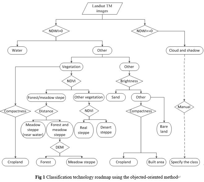
Proposed by Baatz M. And Schap A., remote-sensing interpretation technology using object-oriented is a classification method with target objects as processing units. The principle is that the image is first segmented and merged into homogenous polygons of different sizes according to the spectral heterogeneity between the pixels. Then, the image is classified by setting rules or selecting samples. The classification route in this paper is shown in figure 1. During the classification process, we interpreted the images one-by-one avoiding the problem that the classification rules have different thresholds because of differences in image time and angle, etc. The thresholds of indices were obtained based on their physical meaning, empirics from previous studies and multiple experiments in this remote sensing interpretation process.
The normalized difference water index (NDWI) and normalized difference vegetation index (NDVI)were calculated using the following equations:
NDWI=(G-SW)/(G+SW) (1)
NDVI=(NIR-R)/(NIR+R) (2)
Landsat-5 Bands 5 and 2 were used for SW and G in calculating the NDWI, while the NDVI’s NIR and R variables were represented by Landsat-5 Bands 4 and 3. Both of these indices produce values ranging from -1 to +1.
(1)Water. The reflectivity of water decreases from the visible to near-infrared band, and the reflectivity in the near-infrared band is nearly zero, while the reflectivity of the vegetation in the near-infrared band is very high. The NDWI established according to the aforementioned equation can effectively inhibit vegetation and highlight water information. Then, the water is classified by setting the NDWI threshold.
(2)Cloud and shadow. Although the cloud content was limited to 10% or less when the image is selected, cloud spots and shadows still exist on some images, which causes cloud and water to be confused during the classification process lowering the classification accuracy. For this reason, this study distinguished water from clouds and shadows by following several strategies. First, the vector boundaries of the clouds and shadows in the image were divided in the ArcGIS 10.4 software via visual interpretation. Second, the vector layer was imported into the eCognition 8.7 software, and the NDWI thresholds were set for different vector layers to obtain the cloud and shadow information.
(3)Cropland. Cropland is a type of land cover that has been reclaimed by humans and has a relatively regular shape. It is easier to identity on an image according to its shape. However, after multi-scale segmentation of images, cropland boundaries and object boundaries are often confused. Therefore, the compactness parameter provided by the eCognition software was combined with the same method of cloud and shadow information extraction to accurately obtain cropland during the classification process.
(4)Vegetation. The NDVI is among the powerful tools to extract vegetation information. The specific operation of extracting vegetation using the NDVI is as follows: first, the vegetation information in the image is extracted by setting the NDVI threshold; second, according to the characteristics of forest and meadow steppe with a high NDVI value, the method of distance between adjacent classes is adopted, establishing the rule that the object is meadow steppe within a certain number of pixels near a river to distinguish the meadow steppe along a river and forest. The forest in the high mountainous area was divided by setting a DEM threshold.
(5)Barren. Barren includes two secondary land types, sand and bare land. Sand occurred in widely distributed, very small batches but its reflectivity was high. Hence, brightness was used to distinguish sand and bare land.
(6)Others. For built area and ice, because their areas are relatively small, the main method was to use visual interpretation and human–computer interaction modification.
Comment list ( 0 )

