A recent nationwide study announced in summer 2022 led by the Boston University School of Public Health in US has spelled out a connection between urban green coverage and its impact on human mortality rates.
This detailed study was conducted in urban areas whose findings revealed that perhaps greater efforts at planting trees in large US cities could have prevented between 34,000-38,000 deaths, based on data from 2000-2019. The researchers have calculated that about 15 to 20 deaths per 10,000 seniors could have been prevented between 2000-2019 with a 0.1 increase in the Normalized Difference Vegetation Index (NDVI) across all 35 US metropolitan areas included in the study area.
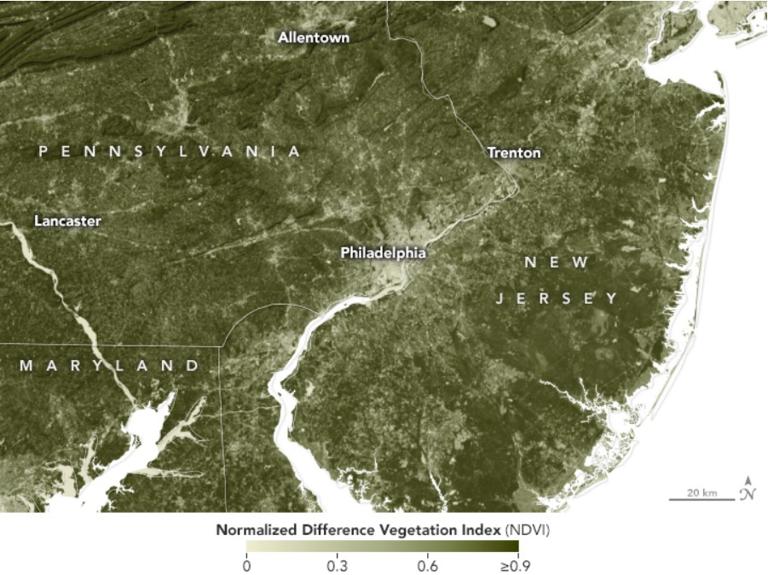
This unique study used population data from the US Census, mortality data from Centers for Disease Control WONDER system and greenness data from NASA’s Landsat satellites to conduct a nationwide health impact assessment. NDVI is a commonly used metric used to estimate the quantity of green vegetation. The researchers used NASA satellite images to examine how the amount of green vegetation has changed between 2000, 2010 and 2019. Since the basis of this study is the use of the satellite based NDVI measurements it could be replicated globally in the future.
Satellite images yield accurate green assessment
The method of NDVI has existed since the early 1970s, and it has steadily grown in its real world application areas. In recent times it has become the standard in using multispectral satellite data to measure plant growth. One of the greatest areas where NDVI has been used widely has been in measuring agricultural yield. The accurate geospatial results offer effective opportunities to national and international organizations to assess what their crop yield outputs will be and potentially to monitor if likely areas may experience drought impacts due to environmental conditions. As technology advances satellites can provide useful information to help valuable research and studies to be conducted and their results suitably implemented.
Green cover enhances quality of life
It has been widely acknowledged that living within a green neighborhood visibly reduces stress for all. In fact several studies have confirmed that separation from nature is detrimental to human development. A scientific study in the Netherlands found that people who lived in residential areas with the least green spaces had a 44 percent higher rate of physician-diagnosed anxiety disorders than people who lived in the greenest residential areas. Researchers from the VU University Medical Center in Amsterdam had conducted the study and they found that among more than 300,000 Dutch adults and children, those living near more “green spaces” tended to have lower rates of 15 different health conditions. Several studies have confirmed that regular and generous use of green spaces is associated with improved blood pressure and cholesterol levels, reduced stress, and overall improved general health perceptions. The British Ecological Society had conducted a research on evaluating benefits of urban green space use during a time of stress through a case study during the COVID-19 pandemic in Brisbane, Australia. The study concluded that increased urban green space use during moments of stress such as the COVID-19 pandemic had the strong potential to greatly reduce stress, anxiety and ill-health caused by an uncertainty like the pandemic.
Trillion Tree Movement
Global recognition of the wide array of plus points in increasing tree cover has led to several greening initiatives all over the world. A significant action plan was launched in January 2020, when the World Economic Forum launched its huge goal to support global green restoration movement in sync with the launch of the UN Decade on Ecosystem Restoration by a determination to foster active efforts to grow a trillion trees by 2030.
The research findings would help urban planners
Incorporating green cover in living areas naturally yield health benefits apart from overall economic, ecological and social upheavals. This is definitely a well-recognized fact. Substantial data to back this understanding has however not been available in ready abundance. In this context this recently published research by the Boston University of Public Health provides valuable quantification of the relation between impacts of an area’s green index on its human life expectancy values.
The researchers want to further build on the study findings to evaluate whether the effect of greenness in mortality is the same across various race and ethnicity groups and also explore local changes in greenness distribution across other urban areas. The study team revealed that overall greenness quotient in the study area has actually increased across time with a 2.86% increase from 2000 to 2010 to 11.11% from 2010 to 2019. These supporting data can encourage local Climate Action Plans by providing a quantitative assessment to the impact local greening initiatives can have on mortality.
Urban planners and local governments can use these findings to assess the positive links to enhance grass root Climate Action Plans strengthened by a public health lens and thereby support suitable policy development. As satellite data continues to make valuable contributions in encouraging greening initiatives in US we certainly look forward to witnessing more geospatial evidence of increasing green cover in times to come from all parts of the nation.
Sources:
Geospatial World
Provided by the IKCEST Disaster Risk Reduction Knowledge Service System
Comment list ( 0 )

