Network mapping and online use of geospatial information have developed rapidly in the past few decades. Almost everyone in the world uses map information, whether one is aware of it or not. Now almost every mobile phone has a location service, and every event and object on the earth has a location. Due to the development of the Internet, the use of this geospatial location data has expanded rapidly. A large amount of geospatial data can be obtained on the Internet and used in network applications and maps for viewing, analysis, modeling and simulation. This paper reviews the development of WebGIS, from the first static online map image to the current highly interactive multi-source web map services, which have been increasingly transferred to cloud computing platform. WebGIS realizes the integration and online interaction among geospatial information, personnel and functions. Combined with the development of technology, this paper attempts to study the trend and interaction between these components, and finally discusses some opportunities and directions.
Historical evolution
U.S. Vice President Al Gore’s 1998 speech on digital earth technology raised people’s awareness of the value of geospatial information and its necessity to provide it on the Internet and access it to many users around the world.Gore's vision is to use technology and people to produce an immersive visual experience in virtual geographic space and time to understand our planet.He pointed out the concern for applications such as developing virtual diplomacy, fighting crime, protecting biodiversity, predicting climate change, and improving agricultural productivity.Interestingly, in the past two decades, technology and collaboration environments have undergone tremendous development, combining people and information, including digital earth, high-speed communication networks, mobile wireless networks, location-based services, cloud computing, and Web GIS.However, we still face many challenges and obstacles, including connecting information around geographic locations, analyzing and processing large geospatial data, discovering and interpreting intelligent information, immersively understanding our digital earth, taking advantage of crowdsourcing opportunities, and visualizing and Disseminate information to the global public in an easy-to-understand way. Since the beginning of the Internet and the first World Wide Web conference in 1994, the interaction between information and people has undergone tremendous changes. Today's network is not just a content technology under development, but also involves content generation, communication and collaboration.
New user needs continue to evolve, which is met in further technological development, which in turn has led to wider use and increased user needs, thus forming an iteration of technological development and user application growth and expansion cycle. In addition, from a technical point of view, the methods and tools for providing maps on the Internet have undergone tremendous changes. The early origins of Web GIS applications were "simple" tools that allowed institutions and individuals to publish maps. User choices were limited to browsing, zooming, panning, and closing layers.Although users are active readers of data, they are passive in uploading information to maps and performing spatial analysis. Today, Web GIS applications have introduced a wider range of functions, including those provided by traditional desktop GIS, but are still expanding to incorporate growing application requirements, and have the advantage of being able to share content and the ability to analyze network map data. In this article, we want to outline the evolution of Web GIS, taking into account the views of designers (experts, scientists) and users (novices and occasional users).
Connotation of Web GIS
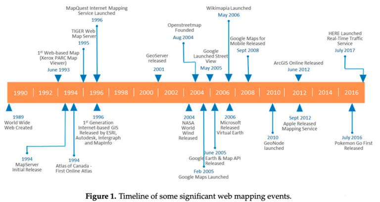
What is Web GIS? In addition to the accepted scientific and technical definitions, we can refer to the content provided by Wikipedia. Web GIS contains three basic elements: geographic data, geographic information and its visualization (map), geospatial software and the Internet. Web GIS is the most common form of online GIS. The development of network map starts immediately after the network is created, mainly in the form of published online map. Parc map viewer is the first web-based map. Up to now, Web GIS has reached an unimaginable level twenty years ago, which is mainly due to the progress of web technology.
In terms of web development, the web is usually recognized by different authors using four generations called web 1.0 to web 4.0 (and later). Generation after generation of general web development has laid the foundation for Web GIS development. It has experienced some different but interrelated or overlapping stages.
Comment list ( 0 )

