Remote sensing imagery is widely used in disaster response due to its easy accessibility and timeliness and can clearly reflect changes in features caused by earthquakes using pre- and post-earthquake image comparisons.
The Mw 7.8 and Mw 7.5 earthquakes that occurred in Turkey on February 6, 2023 caused severe loss of life and destruction of roads and buildings. This event was the biggest earthquake to strike the Eastern Anatolian Fault Zones (EAFZ) since the 1990s.
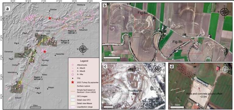
To gain a timely and in-depth insight into the earthquakes, a team of researchers from the Institute of Earthquake Forecasting in Beijing, China, used high-resolution Maxar and GF-2 satellite data to obtain spatial interpretations of part of the rupture zone in the epicenter of this earthquake, as well as seismic landslides and soil liquefaction developed around the rupture zone.
"We searched for feature dislocations and measuring the amount of dislocations, which provided a timely and comprehensive understanding of the earthquake damage caused by this earthquake," said Yueren Xu, corresponding author of the study.
The team initially interpreted a rupture zone of approximately 75 km in length and found that the surface showed a gradual widening of the spreading width and a gradual decrease in the amount of horizontal dislocations to immeasurable levels.
"Secondary hazards such as liquefaction are mainly found in rivers or low-lying terrain at the end of the rupture zone, and landslides are found in valley areas near the rupture zone," said Xu.
The findings are published in the journal Earthquake Research Advances. The researchers proposed that earthquakes in Turkey will not have a direct response on significant magnitude seismic activity in western China. This is due to the continental collision involving various plates plus their contrastive seismically active zones throughout the world. "Despite both China and Turkey being part of the same Eurasian seismic region, they variably exhibit tectonic mechanism dissimilarities," added Xu.
Sources:
PHYS.org
https://phys.org/news/2023-05-high-quality-satellite-imagery-swiftly-reveals.html .
Provided by the IKCEST Disaster Risk Reduction Knowledge Service System
Comment list ( 0 )

