Login   |      Register
English    中文


Soil salinization data set with 30m spatial resolution in the Yellow River Data


Soil salinization data set with 30m spatial resolution in the Yellow River Data

Label :

Date: 2021-01-07

View counts: 5429

Browse document: Browse document

Download Dataset: Log in

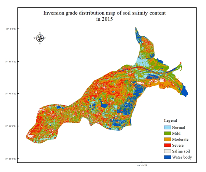
Based on landsat8 oil multispectral data with 30 meters spatial resolution in 2015 and 2019, the soil salinization degree data set in the Yellow River Delta was evaluated by combining the feature space method. The data set shows the degree of salinization in the Yellow River Delta region, helps users understand the spatial and temporal distribution of salinization degree in the region, and provides reference and basis for users and further research.

Topicategory
Earth science
Time begin
2015
Time end
2019
Organization
Institute of Geographic Sciences and Natural Resources Research, Chinese Academy of Sciences
Date creation
2020.12.14
Contributor agency
Institute of Geographic Sciences and Natural Resources Research, Chinese Academy of Sciences
Contributor email
1437008569@qq.com
Country id
CN
Data citation
Soil salinization data set with 30 m spatial resolution in the Yellow River Delta. Disaster Risk Reduction Knowledge Service of International Knowledge Centre for Engineering Sciences and Technology (IKCEST) under the Auspices of UNESCO, 2020.12.14.URL
Data record num
156 MB
Resperson name
Service group of Disaster Risk Reduction Knowledge Service System of IKCEST
Responsible address
A11 Datun Road, Chaoyang District, Beijing
Responsible email
ikcest-drr@lreis.ac.cn
Responsible postcode
100101
Responsible telephone
010-64889048-8006

Data Visualization on Map

Central point longitude
118.785
Central point latitude
37.617
Max zoom level
8
Min zoom level
1
Current zoom level
7


    Sign in for comments!

Comment list ( 0 )


Information evaluation